Mr. Henry Vignaud and His Library
Born in New Orleans on November 27, 1830, to parents of French descent, Henry Vignaud was the oldest of six children. Originally christened as Jean-Héliodore, Henry Vignaud taught in the New Orleans schools for four years before he began his journalistic career. With the outbreak of the Civil War, Vignaud served as a captain in the 6th Louisiana Regiment until the fall of New Orleans when he was captured. After his imprisonment Vignaud fled to France, but never again returned to his native New Orleans.
Vignaud continued to serve the Confederate cause abroad until the end of the war when he was hired by the Roumanian government to serve as the Chancellor of the Roumanian Diplomatic Agency in Paris. However, in 1872 Vignaud entered the service of the United States government, initially serving as a translator but later becoming first secretary to the United States legation. He continued in this capacity until he retired as secretary to the United States embassy and from public life in 1909. At the reception held in his honor, Vignaud was presented with a fund created by the Messrs. Morton, Carnegie, Morgan, and others, intended to secure him for the remainder of his life while he pursued his academic interests.
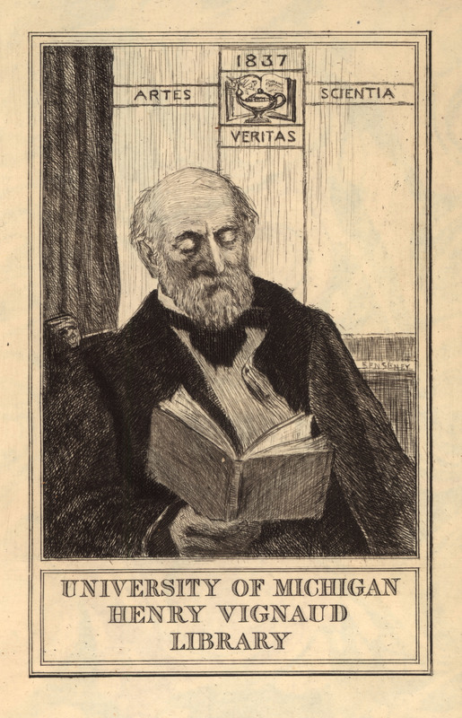
An accomplished scholar and historian, Henry Vignaud developed a strong fascination with the early history of the Americas, focusing on the Columbian Encounter. Throughout his career Vignaud made the acquaintance of many individuals who were equally passionate about America’s early history, including Pierre Margry and Henry Harrisse, who earned themselves the moniker of “Americanists”. In 1908 Vignaud became president of the Société des Americanistes de Paris, a group of individuals who study the cultural anthropology of the Americas. Vignaud’s interest in American history displayed itself in his research and publication of several volumes on the subject of Christopher Columbus and the Toscanelli letter. At the same time he was an avid collector of rare maps, accumulating an impressive collection for his limited means. Vignaud’s personal library grew to include over 1200 maps, atlases, books, and pamphlets dating from the 16th to 19th centuries. His collection featured rare and intriguing works on early American history, as well as other European and French works. During the years leading up to his death on September 16, 1922, Henry Vignaud composed an unpublished manuscript on the history of cartography. To this day, the location of Vignaud’s manuscript is unknown.
Following Mr. Vignaud’s death, the University of Michigan purchased Vignaud’s large personal library from his widow, Louise Compte. In 1923, with the support of Regent William L. Clements, William Warner Bishop traveled to France to make the purchase and prepare the library for shipment. The collections of books, atlases, maps, pamphlets, and other publications were divided between the William L. Clements Library, the Stephen S. Clark Library, the Special Collections Library, and the Harlan Hatcher Graduate Library.
![[Photo of Henry Vignaud in his library]](https://apps.lib.umich.edu/online-exhibits/files/fullsize/9c77ce55e7c0d7bba4f760f4cc82f807.jpg)
"Vignaud, Henry." Dictionary of American Biography. Volume X. Scribners: 1995. 268-270.
Defining the Project
The Vignaud Map Collection at the Clark Library contains many historically important and rare maps. Among these are 188 maps that were published by the 17th century Dutch map publishing firms of Hondius and Janssonius, which are the focus of this research project. While the map collection staff was aware of the significance of these maps, over time it became evident that these maps shared common physical characteristics, or environmental effects, and possible provenance. They all lacked text on their reverse side, which was unusual at the time for maps in atlases. Most of the maps had a Hondius or Janssonius imprint, and were of a similar style and paper. Our theory was that these maps were at one time bound together, based on their shared physical characteristics, such as red chalk drawings on the verso or water damage. We believed that physical and bibliographic analysis would help us to confirm each group as a published atlas. Finally, we hoped that our research would shed light on Vignaud’s interests and intentions as a map collector.
To determine the validity of our theory we carefully analyzed and grouped together maps with shared characteristics. The process for examining the environmental effects, characteristics of the paper, and manuscript markings on the maps from their nearly 400 year history is outlined below:
1. We spent countless hours researching and reading about 16th and 17th century Dutch cartography, printing, and publishing.
2. We created an Excel spreadsheet to track our growing set of data about the maps’ various attributes.
3. The type of data collected includes: title, publisher, author, engraver, sheet size, watermarks (if any), and paper condition.
4. When examining the paper’s condition we looked at characteristics such as specific water damage, rodent damage, aging, manuscript numbers on verso, sprinkles, red chalk drawings, and accession numbers, among other traits.
5. We consulted with Dr. Cathleen Baker, the library’s paper conservator and papermaking expert. After meeting with her, the spreadsheet continued to grow as we learned more about papermaking and printing from her.
6. We carefully checked the authors, engravers, and other bibliographic information against the descriptions in Dutch map bibliographer Peter van der Krogt’s Koeman’s Atlantes Neerlandici, and Mireille Pastoureau’s Atlas Francais, matching our maps to atlases of the period that lacked text.
7. We conversed via email with Peter van der Krogt to inquire about the maps we have that didn’t match any listings in his book.
8. As Vignaud’s personal library forms the basis of the Clements Library’s map collection, we worked closely with the Clements in tracking Vignaud’s materials throughout the libraries at the University of Michigan. We also communicated with other academic institutions regarding their holdings that had previously belonged to Vignaud.
As part of the process we spent significant time creating and updating the maps’ bibliographic descriptions in the catalog. In 1998 a retrospective conversion of our card catalog was done to transfer bibliographic information from the cards into MIRLYN, the library’s online catalog. A preliminary inspection of the records made it apparent that much of the original information was incorrect. This was not surprising, as map bibliographic knowledge has become more accurate with continued research, easier communication between researchers, and the incorporation of new technology.
Understanding Atlas Terminology
- Atlas -- a collection of maps that possess three defining traits (1) the dominance of graphic elements (2) the rough uniformity of map format, design, and presentation throughout the work; and (3) the standardization (generally) from copy to copy in each addition, of composition and arrangement of atlas components (van der Krogt, p.18-9). Gerhard Mercator was the first to use the term in regards to maps. As he states in the preface to his Atlas (1595), “I have set this man Atlas, so notable for his erudition, humaneness, and wisdom as a model for my imitation.” The mythical Atlas that Mercator uses as his inspiration was the great-grandson of Sol, the sun god in Roman mythology, and tutor to Janus, the god of beginnings and transitions (Crane, p.275). It was only later that it became the Titan Atlas holding up the world.
- Appendices/appendix atlas -- Appendix was used by the Hondius, Janssonius, and Blaeu firms for atlases that contained a printed title page and index. Contrary to convention, the maps in the Appendices had no text on the reverse side, or verso, of the map. They were geographically incomplete; by themselves the maps would not cover one particular part of the world or constitute an entire atlas. The Appendix atlases of Hondius and Janssonius are very rare and often had a temporary binding so that they could be disbound and the maps added to other atlases. (van der Krogt, p.123).
- Threatrii/theatrum --a term long used to describe maps or atlases of the world. The map or atlas acted as the stage upon which the world was presented, creating a “theater” for the audience. It was first used in early modern times by Abraham Ortelius for the title of his work, Theatrum Orbis Terrarum (Theatre of the World), considered by many to be the first modern atlas. Theatrum, as used by Henricus Hondius and Johannes Janssonius, refers to their three part experimental atlas of France (1631 and 1633), Germany (1632), and Italy (1635).
- Composite/composed atlas, or atlas factice -- a custom atlas, typically compiled at the behest of a private person(s), and not commercially produced by a publisher.
Crane, Nicholas. Mercator: the Man Who Mapped the Planet. New York: H. Holt, 2002.
Koeman, C, and P. C. J. van der Krogt. Koeman's Atlantes Neerlandici. New ed. 'T Goy-Houten: HES & De Graaf Publishers, 1997.
Results and Next Steps
The goal of our project was to group together atlas sheets with similar characteristics based upon an analysis of the paper. Our assumption that these maps were at one time bound together was confirmed. With additional bibliographic analysis we recreated four atlases and were able to substantiate the following:
1.) Only one of the four recreated sets matched known titles.
2.) There are gaps in the handwritten pagination on the maps. This could suggest that Vignaud may never have had complete versions of these atlases and only purchased what was available from a map dealer or other collector.
3.) The broken atlases that the maps came from were almost certainly disbound, or broken, before the University purchased them. It is also probable that they were broken even before Vignaud acquired them. Some of the maps that we determined go together also have conflicting characteristics, meaning that they were most likely not always together.
4.) The most surprising and interesting finding of our research is that 45 of our 188 maps did not match any listed in Koeman’s Atlantes Neerlandici or any other sources. Many of these maps are variants of those found in van der Krogt, because they lack text on the verso. Especially notable are two maps by the great cartographer Mercator, one of Anjou and one of Burgundy. Seven of these forty maps did not match the four recreated atlases.
Going forward, we plan to do further research to determine what the possible map titles are that would fill in the “gaps” in our atlases. With that information we will query map listservs, search Worldcat, other library catalogs, and map dealer and auction catalogs to ascertain who owns the other maps from the atlases in our project. Beyond Henry Vignaud’s interest in the Columbian Encounter, we still do not know much about his preferences as a collector and why he owned these particular maps. Further research of his papers at other institutions and locating his unpublished manuscript may shed light on this question.
Ultimately, our findings agree with van der Krogt’s assertion, “that the ideal copy does not exist either for these folio atlases in particular or, arguably, for most folio atlases in general” (Van der Krogt, 1996, p.150).
Van der Krogt, Peter. “Amsterdam Atlas Production in the 1630’s: A Bibliographer’s Nightmare.” Imago Mundi, Vol. 48 (1996).
History
Composite Atlas of France (RC)