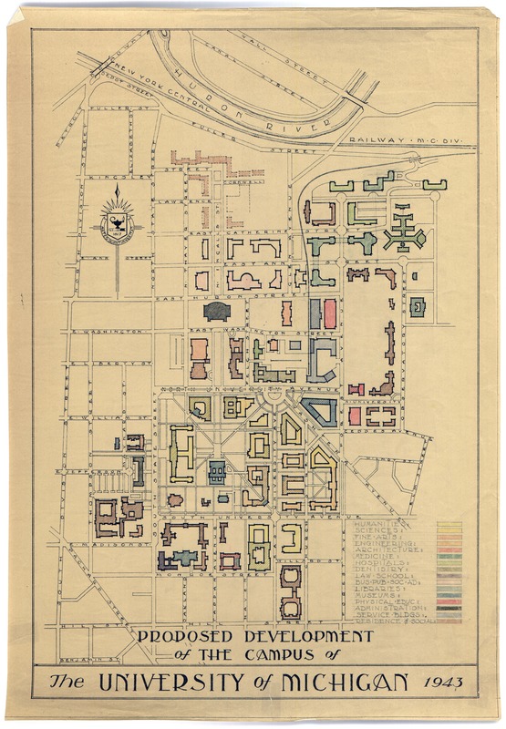
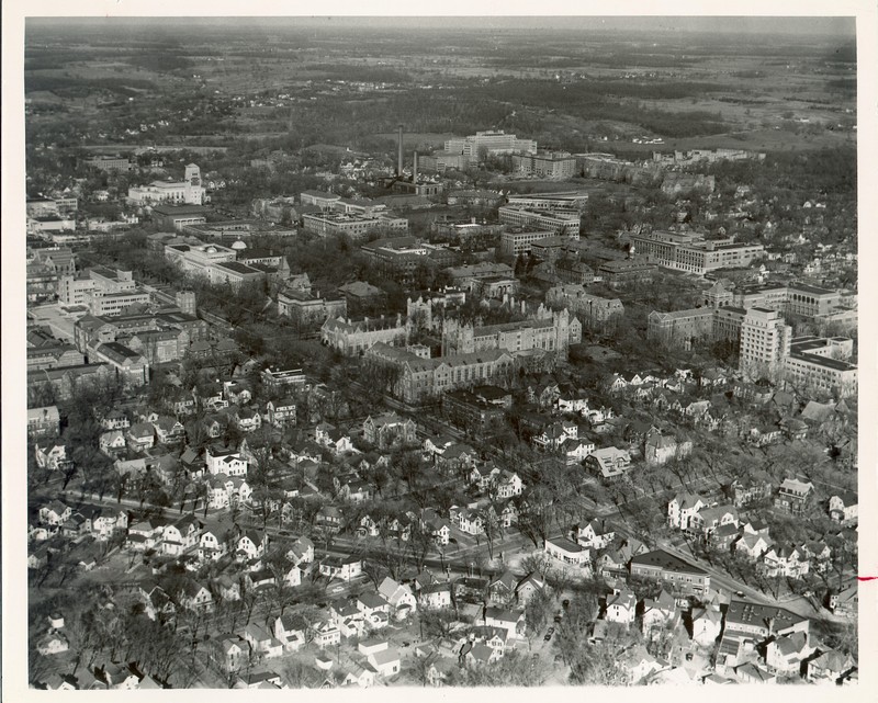
1943 Plan

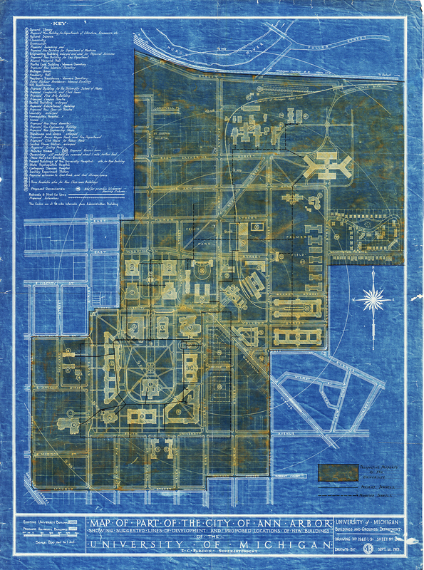
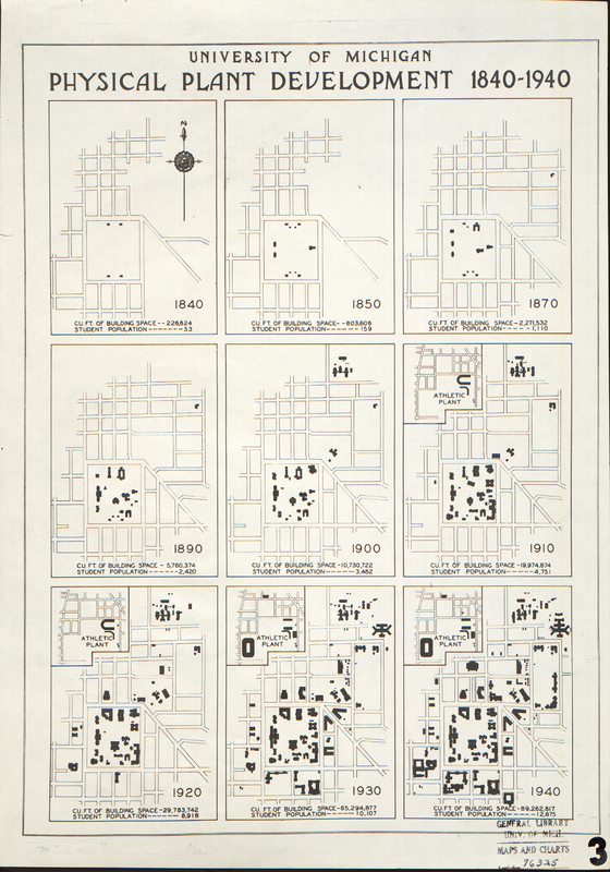
The rapid and unguided expansion of the 1920s demonstrated the growing need for a new plan to oversee the development of campus. With the outbreak of the Second World War construction efforts ceased, giving the university the opportunity to re-examine its changing needs and devise a plan for the postwar era. Two plans were created during the span of the war, one in 1941 and the other in 1943. Both were updates to Burton’s plan and those of Pitkin and Mott, and reflected the changing priorities and conditions of the University, including the increase in the student population between 1910-1920. The 1943 plan sited many of the projects in the postwar era and continued to guide planning throughout the 1950s (Mayer, 1118-120).


hs16937.jpg

The University Building and Grounds Department created this detailed and very accurate blueprint plan to show the current campus, proposed buildings, and prospective property for campus expansion. Note the placement of music, fine arts, and theatre buildings near Hill Auditorium with the campanile and clock tower in the middle of the square in Ingalls Mall (Mayer p. 92).

hs16932_mapofcampusbuildingsandstores.jpg

This 1929 map of the central campus area provides a straightforward depiction of campus. Just as interesting is the identification of nearby businesses.

bhl_hs13079_full_4597_3565__0_native.jpg

In this 1937 aerial view, both the old and new are visible in this aerial photograph of campus. University Hall, the Museum's Buildings, old Mason Hall, and others are still visible. The Burton Memorial Tower was completed in 1936 and an elevator or crane is visible in front of it.

bhl_bl001820_full_6961_4800__0_native.jpg

Of note in this aerial photograph from the 1930s is the Law Quadrangle in its final stages of construction. Recently completed buildings include the University Museum (1928), Women's League (1929), Lorch Hall (1929), and University Elementary School (1929).

39015095396357.jpg

These concise comparative maps illustrate the growth of campus from 1840 to 1940 and include student enrollment figures. The largest increase in student population during that period occurred between 1910-1920.

proposeddevelopmentofcampus.jpg

In 1943, the University submitted a report to the governor of Michigan, outlining the University’s needs for expansion. This plan is a variation of the map submitted as part of that report. It is a compilation and update of the Burton and Pitkin and Mott plans of campus, and this revised version guided post-war campus growth for the next 10 years. It is color-coded to distinguish buildings by discipline and diagonal lines denote existing buildings (Mayer, p. 118).

mayeraerialview.jpg

This aerial photo shows the central 40 acres from the west as it appeared in 1942. It is a blend of the twentieth- century buildings, such as Angell Hall, the library, and the Natural Sciences buildings, with older nineteenth- century buildings, such as University Hall, Haven Hall, Barbour and Waterman Gymnasiums, and the Engineering Shops Building. (Mayer, Fig. 5.34, p. 119).

CampusoftheUofMwarboardplant.jpg

This map was originally published as part of the University of Michigan Plant and Personnel Protection Organization during the early years of World War II by the War Board Plant and Personnel Protection Committee. They were responsible for creating and managing the university's emergency protection and coordinating with the local Civil Defence Councils.

bhl_bl001818_full_6961_4800__0_native.jpg

This 1949 aerial photograph gives an extensive view of most all of campus. Alice Lloyd Hall and Business Administration Building are in final stages of construction. The Administration Building (LSA) was completed in 1948. In the foreground where there are currently houses, construction would soon begin on South Quadrangle dormitory (1951).

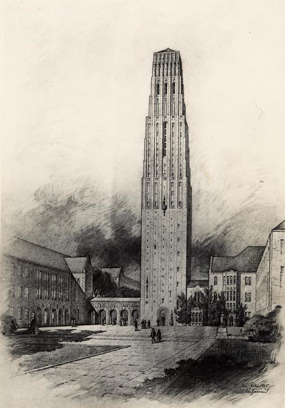
The Proposed Music School
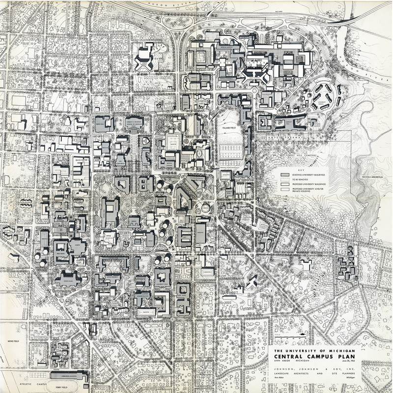
1963 Plan