Creating a Campus
Traversing across its streets and sidewalks, too often we are rarely conscious of the methodical planning that has shaped our campus through the course of its development. Campus planning helps us to define the university, its mission and, ultimately, our experiences of both. Through the incorporation of diagrams, photos, and maps, Creating a Campus details the university’s founding and ultimate move to Ann Arbor, and highlights the major master plans for campus, including those that were never implemented.

The Founding (1817-1837)
History of U-M in Detroit
The Catholepoistemiad, the school that became the University of Michigan, was created in Detroit in 1817. Since 1805, Father Gabriel Richard had been trying to organize primary education within the Territory of Michigan. Governor Lewis Cass appointed territorial judge Augustus Woodward to create the first school system, and Woodward, along with the Reverend John Monteith and Fr. Richard, created the Catholepoistemiad. On August 26, 1817, it was officially established by the territorial legislature and was one of the first publicly funded school systems in the United States. It served the main territorial settlements of Detroit, Frenchtown, Mackinac Island, and Sault Ste. Marie. The first school building was located on Bates Street, between Congress and Larned (see the image below). The new school was based on Napoleon Bonaparte’s newly created University of France, which was organized with the university at the center of a statewide system of primary, secondary and college education.

In that same year, the Treaty of Fort Meigs was signed between the United States and the Ojibwe, Odawa, and Bodewadmi tribes. Under the treaty, 1,920 acres of land were granted by the tribes for the use of the newly established college in Detroit. One of the tribes’ provisions for granting the land in the treaty was the belief that, “they may wish some of their children hereafter educated.” The $5,000 proceeds from the eventual sale of a portion of the land in 1834 were placed in a general fund and were central in the early functioning of the university, including the move to Ann Arbor in 1837.


The Move to Ann Arbor & the 1840 Plan

Moving to Ann Arbor
In March of 1837, the university in Detroit was offered two parcels of land in nearby Ann Arbor by the Ann Arbor Land Company. The regents selected Site B (see below), which is the core of today’s Central Campus (Duderstadt, p. 4). The chosen plot was largely made up of level farmland and peach orchards. The majority of Site A was later acquired and incorporated into the campus in the 1970’s.

A plan for campus development was needed, and in 1838 the regents hired architect Alexander Jackson Davis. Soon thereafter they adopted his plan for the new campus, which featured Gothic style buildings set in a park-like setting (see Davis’s plans below). One of Davis's ideas included a signature building facing State Street with expansion around the north east and south peripheries. Sadly, the plan was later vetoed due to financial concerns.


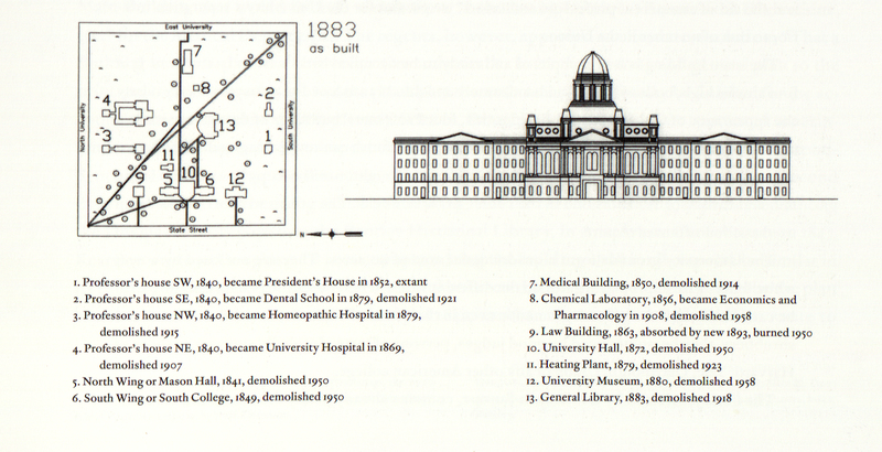
With the University growing in its new Ann Arbor location, a new plan for campus development was commissioned in 1840. Unfortunately, no copies of the original plan, which was likely created by Harpin Lum, exist today, but the design is preserved on the 1854 Pettibone map (see below). The main feature of the 1840 plan was a row of buildings facing State Street with professors' houses along North and South University Avenues, an idea which guided the development of campus for the next 40 years. The plan also included botanical gardens on the east side of campus. One of the most significant changes to the university during this period was the incorporation of applied research and the sciences, which influenced the decision to build specific buildings, such as the Detroit Observatory (1854) and the Medical Building (1850). Over the next 30 years, several buildings were added, but were not placed according to any specific plan.


First buildings
As the university began to grow in its new home, among some of the earliest buildings to appear were the Detroit Observatory, the President’s house, and the Medical Building. Over the ensuing two centuries, major changes and differing plans changed the face of campus. Yet, two of these original buildings still stand today and remain some of the most important buildings on campus, the Detroit Observatory and the President’s House.
Detroit Observatory
President Henry Tappan wanted to make the University of Michigan into one of the first and foremost research institutions in the country. In support of this ideal and with the assistance of the merchants of Detroit, money was raised for the construction of an observatory in nearby Ann Arbor. The observatory would allow for precise timekeeping, which was critical for precise mapping, safe train travel, and for trading in stock exchanges. The observatory was placed on a hill away from campus so as to avoid disturbances to their astronomical observations. Built in 1854, its main telescope was the third largest in the world and today the building remains the second oldest on campus and is still open to visitors.


The President’s House
In March of 1840 the university completed construction on four houses for professors. Two faced North University Avenue and two faced South University Avenue. The houses were all built to the same plan and had the same external appearance. Today only one of these houses, the southwest house, remains standing, but it has become one of the most important buildings on campus, the President’s house. Throughout the years, many changes have modified the look of the house, including the addition of a third floor and other renovations, but the original structure and character is still visible.

The Medical Building
To accommodate the continually growing school, a medical building was completed on the east side of campus in 1850. A chemical laboratory was placed just behind it, granting easy access to medical and other students. The Medical Building was built in the Greek Revival version of classicism. The outbreak of the Civil War brought the end to the “visual cohesiveness” of campus, as the architecture of the buildings moved away from Classicism first and later away from campus planning.
As the medical department grew into the beginning of the twentieth century, a new medical building was needed and the old building was superseded. A fire in 1911 destroyed the west half of the original building and while alumni tried the raise funds to protect and restore the eastern half, it was decided that the Medical Building would be razed in 1914.

Growing the Campus: 1850s - 1869